According to a Cabinet Office report, the Sanriku coast of northeastern Japan is known as a place that tsunamis strike again and again. Three great tsunamis reached it between the Meiji era and 1960, and older records suggest a tsunami about once every 46 years on average before that.
Each disaster left grief, and also a question: how do you make the next generation remember a danger that may not return for decades? This article follows the Iwate coast from 1896 to 2011 through that question.
1896: a weak tremor and a great wave
At 19:32 on 15 June 1896, an earthquake struck off Sanriku, about 170 kilometers east of Miyako. According to the Japan Meteorological Agency (JMA), the shaking reported in Hokkaido, Tohoku, and Kanto was weak, about intensity 3 to 1. The magnitude is estimated at 8.2.
About thirty minutes later, a huge tsunami reached the Pacific coast of Tohoku. Its greatest run-up height, 38.2 meters, was recorded at Ryōri village, now part of Ōfunato City in Iwate.
The JMA explains that the fault ruptured slowly for about 100 seconds over a very wide area. Such earthquakes shake the ground only moderately but can generate destructive tsunamis. Scientists call this kind of event a "tsunami earthquake."
The Cabinet Office report notes that the day was the fifth day of the fifth month in the old lunisolar calendar, the Boys' Festival. Villages were also celebrating the previous year's victory in the war with China, together with returning soldiers. People felt a gentle, long tremor but paid it little attention.
The losses were immense. In figures the JMA cites from the Cabinet Office, 18,158 people died in Iwate Prefecture and 2,943 were injured.
The JMA's list of damaging earthquakes gives 21,959 deaths in all. In Iwate, about half of the coastal households and a quarter of the coastal population were lost.
Officials and police officers were among the dead, and buildings for village government, schools, and communication were also damaged. This made relief and recovery even harder.
Moving uphill, and moving back
After 1896, some communities rebuilt on higher ground. The Cabinet Office report counts 43 relocations, but only seven were moves by a whole community.
Most were made by individual households; a few were group moves proposed by local volunteers and paid for with donated relief money. Relocations led by the national government, the prefecture, and the villages had to wait until 1933.
In Hongō, in Yoshihama village, the village head, Niinuma Busaemon, and others planned a move to higher ground. They first moved a low-lying road up the hillside and built houses along it. In 1933, according to the report, Hongō escaped damage.
Many other households drifted back to the shore. Researchers cited in the report listed the reasons: fishing families lived too far from the sea, high ground lacked drinking water, and roads were inconvenient. Attachment to ancestral land also played a part, and the report notes that returns became noticeable about ten years after the disaster, because tsunamis were not frequent.
The small fishing hamlet of Aneyoshi, now part of Miyako City, shows how memory could vanish. In 1896 every house was swept away and only two people survived.
Young people from nearby villages came to carry on the households. None of them had experienced the tsunami, many lived in huts on the shore, and in 1933 the hamlet was destroyed again.
Words carved in stone
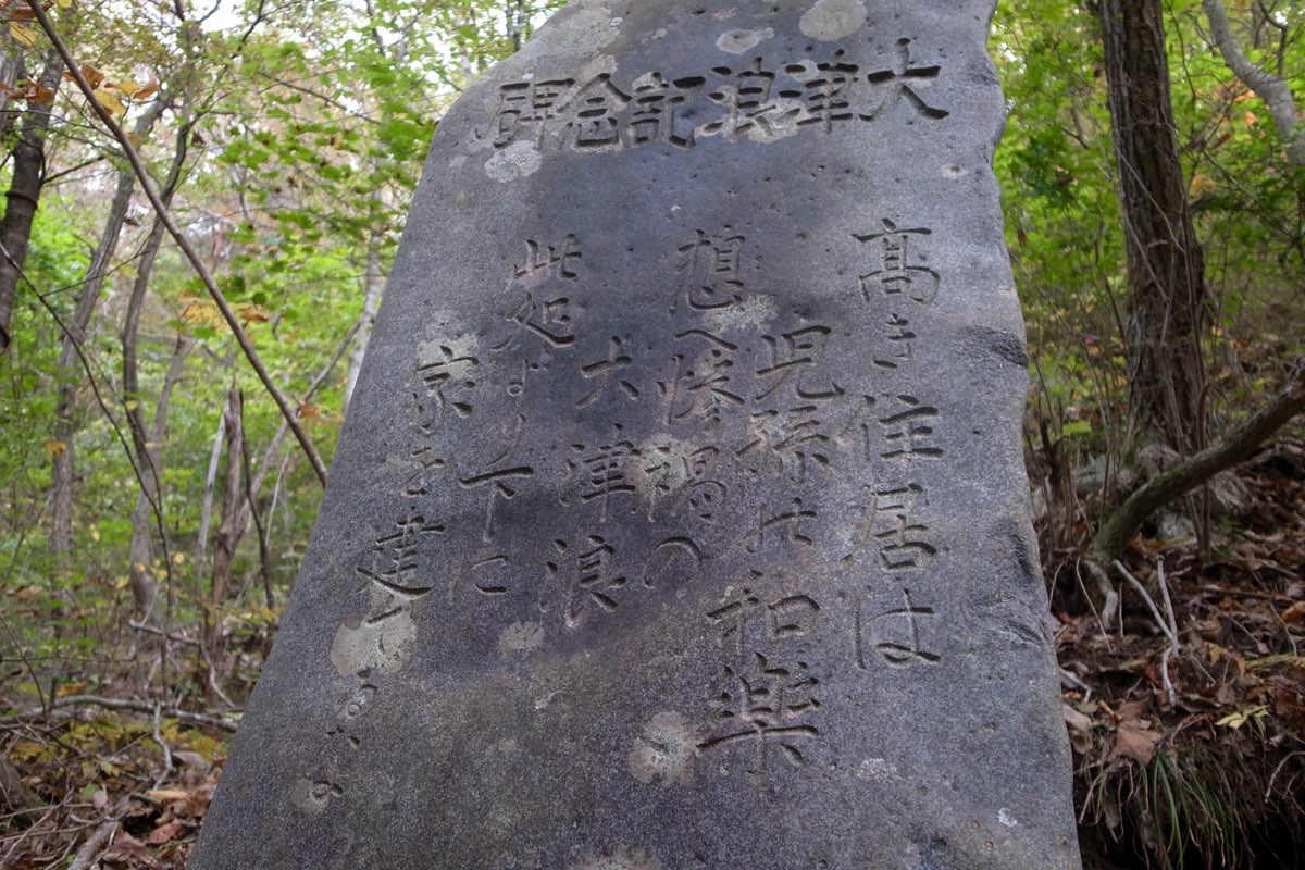
Memorial stones went up along the coast after 1896, but most did not warn. According to the Cabinet Office report, a survey of 124 Meiji tsunami stones found that 101 recorded nothing beyond the date of the tsunami and the monument's title. Twenty bore the names of victims, and none was written as a warning to later generations.
Home Minister Itagaki had urged in 1896 that stones should do more than record the disaster's horror. He wanted them to pass on signs of an approaching tsunami to descendants. Stones written to hand on experience appeared in large numbers only after the 1933 tsunami.
That tsunami struck before dawn on 3 March 1933, after an earthquake the JMA lists at magnitude 8.1. It lists 3,064 people dead or missing.
Iwate Prefecture's online archive, Iwate Shinsai Tsunami Archive, collects the words of these stones. At Aneyoshi, a stone reads: "High dwellings bring peace and happiness to our descendants. Remember the calamity of the great tsunamis. Do not build houses below this point." It adds that in both 1896 and 1933 the tsunami reached this spot, and that only two and then four people survived.
Other stones speak in the same voice. A 1934 stone at Kosode, in Kuji, says that tsunamis have come periodically since ancient times and that residents must long remember.
A stone in Ōfunato tells people to expect a tsunami once every thirty or forty years. One in Kamaishi, erected in 1957, says simply that human beings are forgetful and asks those who see it not to forget.
At the village of Taro, the 1933 tsunami reached a height of up to ten meters. According to the archive, the national and prefectural governments favored moving the village uphill, but in 1934 the village began a seawall at its own cost. With later prefectural and national support, it eventually grew to ten meters high and about 2.5 kilometers long.
Lessons that can mislead
Memory can also mislead. An old saying held that "there are no tsunamis in the season of green leaves," and in 1856, according to the Cabinet Office report, people at Ōtsuchi trusted it and were caught off guard.
The 1960 tsunami from a great earthquake in Chile arrived with no local shaking at all. The JMA lists 142 people dead or missing in Japan, and in Ōfunato 53 people died or went missing. A stone in Miyako carries the lesson: even without an earthquake, if the tide draws back strangely, flee to high ground.
The Cabinet Office report warns that each tsunami has its own character. Teaching one feature, such as the sea drawing back first, as if it always happens can fix a false image in people's minds.
A teaching handed down in families on the Sanriku coast, tsunami tendenko, puts the emphasis on action instead. According to the JMA, it means that when a tsunami comes, each person should flee to high ground at once, on their own. It grew from experiences in which whole families died while trying to help children and elderly relatives. It is not about abandoning others: by each fleeing separately, all can survive.
2011
At 14:46 on 11 March 2011, a moment magnitude 9.0 earthquake struck with its epicenter off Sanriku. The National Police Agency describes it as the largest earthquake ever recorded in Japan. The tsunami it caused struck the Pacific coast of Tohoku and other areas.
In its report as of 1 March 2026, the Fire and Disaster Management Agency counted 5,147 dead and 1,106 missing in Iwate Prefecture, and 19,508 houses completely destroyed. Its death figure includes people recognized as disaster-related deaths. These are deaths from illness caused by the physical strain of evacuation and similar hardships.
The Reconstruction Agency separately counts 472 disaster-related deaths in Iwate as of 31 December 2025. Nationwide, the Fire and Disaster Management Agency's figures, which also include related deaths and damage from aftershocks, are 19,787 dead and 2,549 missing.
Some earlier preparations held. Iwate Prefecture's archive records that the Fudai floodgate, 15.5 meters high and completed in 1984, together with the Ōtanabe seawall, was noted for protecting the village. The village head who pushed for it had himself lived through the 1933 tsunami.
In Hirono, a 12-meter seawall completed in 2010 stopped a 10-meter tsunami in the Kawajiri district. The town was the only coastal municipality in Iwate, Miyagi, and Fukushima with no one killed, missing, or injured. The prefecture credits both the seawall and the strong tsunami-preparedness awareness shared by local government and residents.
Visiting today
The Great East Japan Earthquake Tsunami Memorial Museum, nicknamed "Iwate TSUNAMI Memorial," stands in the Takata-Matsubara Tsunami Memorial Park in Rikuzentakata. According to Iwate Prefecture, under the theme "protect lives, and live with the sea and the land," it displays the history of tsunami disasters on the Sanriku coast, along with photographs, video, and objects damaged in 2011, to pass on the facts and lessons of the disaster.
Admission is free. Opening times and closures can change, so check the museum's official website or Iwate Prefecture's page before visiting.
Sources
- 明治三陸地震津波Japan Meteorological Agency, Sendai Regional Headquarters
- 過去の地震津波災害Japan Meteorological Agency
- 報告書(1896 明治三陸地震津波)Cabinet Office, disaster lessons expert panel
- 1896 明治三陸地震津波 報告書 はじめに内閣府 災害教訓の継承に関する専門調査会
- 1896 明治三陸地震津波 報告書 第1章 三陸地方の津波災害概要内閣府 災害教訓の継承に関する専門調査会
- 1896 明治三陸地震津波 報告書 第6章 明治三陸地震津波災害からの復興内閣府 災害教訓の継承に関する専門調査会
- 1896 明治三陸地震津波 報告書 第7章 明治三陸地震津波災害の教訓と総合的津波防災対策への示唆内閣府 災害教訓の継承に関する専門調査会
- 災害伝承/石碑に刻まれた伝承・「教訓」(いわて震災津波アーカイブ~希望~)岩手県
- 災害に備え、闘ったものたち(いわて震災津波アーカイブ~希望~)岩手県
- 平成23年(2011年)東北地方太平洋沖地震Japan Meteorological Agency
- 第1項 東日本大震災の被害状況及び主な警察活動National Police Agency
- 平成23年(2011年)東北地方太平洋沖地震(東日本大震災)の被害状況(令和8年3月1日現在)第166報総務省消防庁
- 東日本大震災における震災関連死の死者数(令和7年12月31日現在調査結果)復興庁・内閣府(防災担当)・消防庁
- 東日本大震災津波伝承館施設の概要岩手県